Well, The Old Farmers Almanac is correct at the moment. They predicted above average rainfall for our area in early to mid November. After a dry October, we are now getting river-raising levels of rain. Two inches (5 cm) of rain is predicted for Sunday the 4th, and a break is not forecast until Thursday. Another three days of rain will follow! The rains began on the First. 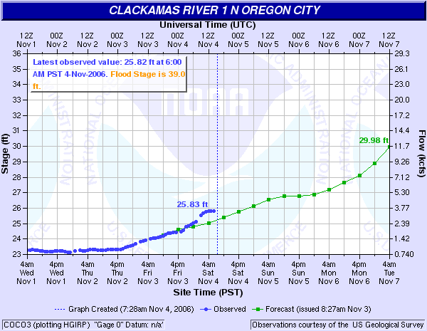 Shown above is the National Weather Service river levels chart of this morning, and the results are clear. Green is predicted river levels and blue actual results. The gauge is located at the South Fork Water Intake just upstream from us. Our levels are perhaps a foot less. If the rate of river level increase holds until Friday, which is possible but not guaranteed, then a higher than average flood is on its way.
The gauge was installed in 2002, so our figures for the earlier floods are approximate. 1996 saw the three highest flood levels in our time here. The highest was about 12 ft. (3 m.) above 'average' winter high water, and around 27 ft. (8.25 m.) above summer lows. In other words, a few inches below the rafters on the overhang of the house on the river side. The highest floods result from frozen soil followed by low elevation snow followed by a sudden warmup and heavy rains for days.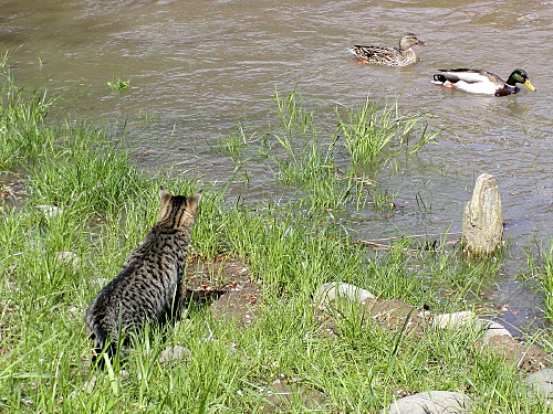
The picture above shows a lesser flood in April 2002 of 'average' proportions. The mallards were attracted to fresh dabbling grounds and our cat Jigs keenly yearned for a meeting with them, but such was not to be. The picture was taken in our labyrinth.
Saturday, November 04, 2006
Rising Waters
Subscribe to:
Post Comments (Atom)
No comments:
Post a Comment