The Northwest Coast of the US is earthquake prone. Unlike frequently shaken California, here the tectonic forces build up over the centuries until very large quakes occur. Small and medium quakes do occur, but rarely and the stress and strain keeps accumulating. The major quakes may be as large as any on Earth.
The last major quake offshore occurred January 26th 1700, dated by tsunami records fron Japan and tree rings here. The Japanese records of the time state that the waves kept arriving for 18 hours and were up to 10 ft. (3 M.) high. On the Northern California to British Columbia Coasts, blocks of land dropped 15 ft. (4.5m) and more, drowning forests and marshes, which were then covered in coarse sand brought in by a tsunami which took only a few minutes to arrive.
It is thought that the entire length of the Cascadia Subduction Zone lurched in this event - a length up to 685 miles (1100 km.)! Entire Native American villages were rubbed out, and Native tales of the event survived and have been recorded.
Damage nowadays from such a quake could range from California to Canada and would be in the many billions.
A magnitute 5.6 earthquake occurred January 11th 2006 near the Blanco Fracture Trasverse Fault edge of the Juan de Fuca plate 143 miles off the Oregon Coast. Depth of the quake was 6.2 miles (10 km). No tsunami or damage resulted due to the location and size of the quake. This one was small compared to the really big ones of the more distant past.
Sunday, November 19, 2006
Earthquake!
Cormorants
The first sighting of double-crested cormorants happened this past Friday, November 17. Most cormorants are seabirds, but this one lives and nests inland as well, here in the West as well as on the lakes of the Plains States east down the Great Lakes and St. Lawrence.
These birds are mostly black, goose sized but slender, and up to nearly a yard (9 dm) tall. Weight is up to 5.5 pounds (2.5 kg).These birds swim low on the water, seeming smaller because of this. From the water's surface they leap and then dive into the water to start chasing their fish prey. Surprisingly their feathers are not waterproof. It may be that this makes them less buoyant and faster underwater. They are often seen holding their wings outstretched apparently to dry them. This habit is unique among our local birds, and is no doubt needed without the waterproofing of most diving birds. Two small crests of feathers on the head lead to the name.
We first noticed them about 8 years ago, when they seemed to be strictly winter visitors. This past season they stayed into late Spring. This is one bird whose numbers are increasing, and is actually expanding its range, especially in the Midwest where introduced fish are providing food absent before. Despite much useful habitat for them, they are migrants here.
They seem wary and I haven't gotten a photo yet. As soon as possible a fresh photo or two will be posted.
In ancient times and up into the 1600's it was thought cormorants were a type of raven. The Ancient Greeks called it the bald raven, and the Romans sea raven. In the Germanic languages similar names were originally attached to these birds. Crested kinds were called shags for the topknot, but with the discovery of more species worldwide the distinction and the naming has not held. Indeed one widespread species, the great cormorant, has no crest in Europe but does in Asia.
Thursday, November 09, 2006
Scattered Flooding in Pacfic Northwest
Roads, trailer park gone; other areas escape damage
Days of heavy warm tropical-origin rain has fallen erratically across the Pacific Northwest, with mountain and coastal areas getting far more than the central lowlands. The uneven distribution of the rainfall showed with record flooding on some rivers, and little elsewhere. The Clackamas River rose to levels less than floods of of the past two years. The Willamette and Columbia, the two largest rivers of the region, saw only minor flooding. Elsewhere, especially on mid-sized rivers, the results were catastrophic.
Lee’s Camp, a mobile home park / resort on the Wilson River in the Coast Range mountains, was mostly washed away, with structures never before damaged now destroyed and trailers, some of them primary residences, floating off down the Wilson. This was record flooding. The Sandy River, which originates on Mount Hood, took out houses, and stranded a illegal campful of homeless men who had to be rescued. Higher up the mountain, near Zigzag, the Sandy removed parts of Lolo Pass Road.
Some of the most astounding flood effects came on the White River on the south side of Mount Hood. Like the Sandy, it heads in the glaciers high on the mountain. This makes both rivers subject to glacial outburst floods and generally higher flood levels due to snow and ice melt during these warm rains. Highway 35 at White River is now buried under grit, gravel and boulders of up to ten tons and more. The bridge over the river is still there but is buried and the river is to the east running in a new twenty foot deep channel. Its guesstimated that a million cubic yards of material was on the move in the White River Outwash Plain. The same highway near Pocket Creek Snowpark now has Clark Creek and Newton Creek both running down it. These two washouts has isolated Mount Hood Meadows Ski Resort from the outside world. Highway officials have set up plans for damage assessment but until this is done there is no telling how long repairs will take. Officials are hinting at the need for Federal dollars, which implies yet more time. And with winter snows just beginning, the timing could not be worse.
This is only the most recent of such outwash events at the White River crossing! This is the most rapidly eroding part of Mount Hood, where deep fragmental deposits are easily undercut and moved by the river. The first such event happened over eighty years ago, just a month after the highway first opened. A winter storm - in August! - hit the mountain and gave highway engineers their first taste of rebuilding at this spot. The wooden bridge was gone. Repeats of this occur about once a decade. To view a good source for pictures of this weeks damage from a local TV station, click here. Since this was posted yesterday, a good overview has been posted in a blog connected to Mount Hood Meadows by Dave Riley. Having toured all the washouts with officials, an informed report was possible, and pictures have been promised in the next day or so. Repairs are already underway on the Hood River approach, but the White River side will take more time.
Here is a link to a Google hybrid map of the area. A gray stripe of glacial outwash clearly shows crossing 35 south of Mount Hood, and the road is blocked from there to a point just north of the green arrow. Also to get an impression of the area, try a Google Earth search for "Highway 35, Mount Hood, OR". Rotate 180 degrees and follow highway 35 back. 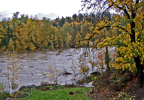
Flooding and Fall Color From Our Location
Elsewhere, the towns of Nehalem and Tillamook on the tourist-dependent Oregon Coast have a good deal of muddy flooding and some road damage. North in Washington State flooding, landslides, and washed away homes were widespread. The elk hunting season was in full swing and an unknown number of sportsmen are cut off by landslides and washed out roads. Official guesstimates are that a thousand are stuck in the woods with their vehicles. As many planned to stay in camp a week, not all are ready to be rescued. Some roads will be fixed quickly. Southern Oregon was out of the main storm path and has seen few problems.
Amid the sensationalism of news reports, remember the scattered nature of the flooding. While some spots did see record water levels, others were far from it and saw little or no damage, even for areas that often flood.
Saturday, November 04, 2006
Rising Waters
Well, The Old Farmers Almanac is correct at the moment. They predicted above average rainfall for our area in early to mid November. After a dry October, we are now getting river-raising levels of rain. Two inches (5 cm) of rain is predicted for Sunday the 4th, and a break is not forecast until Thursday. Another three days of rain will follow! The rains began on the First. 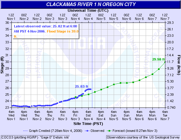 Shown above is the National Weather Service river levels chart of this morning, and the results are clear. Green is predicted river levels and blue actual results. The gauge is located at the South Fork Water Intake just upstream from us. Our levels are perhaps a foot less. If the rate of river level increase holds until Friday, which is possible but not guaranteed, then a higher than average flood is on its way.
The gauge was installed in 2002, so our figures for the earlier floods are approximate. 1996 saw the three highest flood levels in our time here. The highest was about 12 ft. (3 m.) above 'average' winter high water, and around 27 ft. (8.25 m.) above summer lows. In other words, a few inches below the rafters on the overhang of the house on the river side. The highest floods result from frozen soil followed by low elevation snow followed by a sudden warmup and heavy rains for days.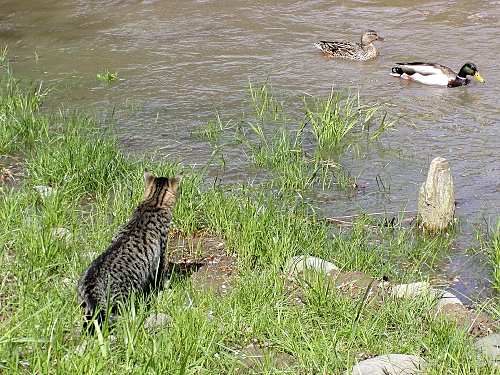
The picture above shows a lesser flood in April 2002 of 'average' proportions. The mallards were attracted to fresh dabbling grounds and our cat Jigs keenly yearned for a meeting with them, but such was not to be. The picture was taken in our labyrinth.
Friday, November 03, 2006
Nutria in the Petunias
There was an interesting observation yesterday in the heavy rain we seem to have settled into. A nutria (an import from the far end of South America), perhaps flushed from his riverside den by the rising water, discovered some patches of petunias. These were about done flowering for the season and needed to be pulled for the compost pile, having barely survived a light frost. The nutria found them a gustatory sensation, and began first chewing them off and then pulling them up. Upon inspection the following morning it was found that he(?) consumed only the tough bases, leaving the smaller stems and leaves in heaps ready for the gardener to pick up! Some plants were pulled up by the roots. The only other animal which has been seen here eating stem bases (of spring grass) was beaver.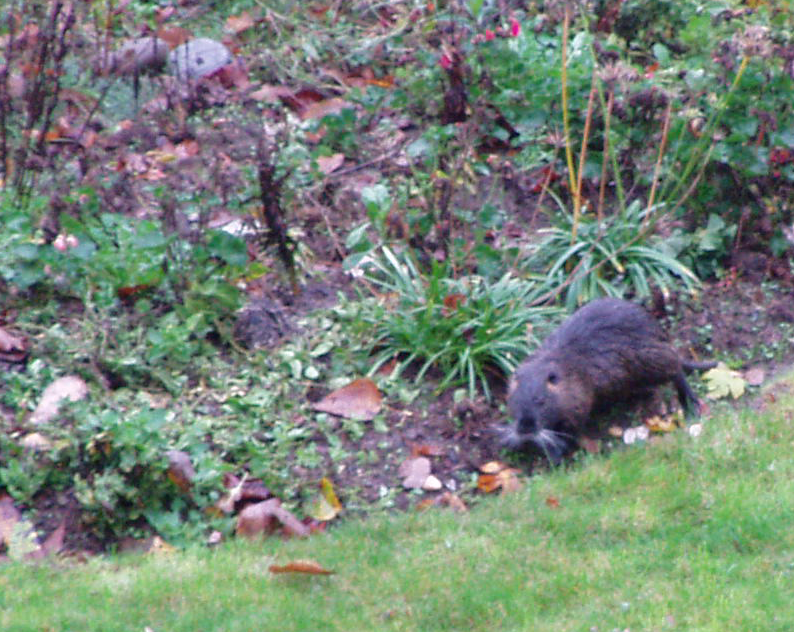
Nutrias are perhaps best described as vegetarian and partway between a beaver, a rat and especially the muskrat, and related to all three. They are aquatic and if lacking predators overuse their habitat by constant grazing. Originally imported into several parts of the USA as a boon to the fur industry, this fur-bearing animal was actually trapped heavily for the fur trade, with up to 1.8 million harvested in a single year in Louisiana alone. Fur fashions change and now demand and prices are so low that the nutria are rarely trapped and have reached pestilential status everywhere. Some states have proposed eradication as a solution to the damaged wetlands they cause. Others see them as an unsolvable nuisance.
Before the old apple tree fell, nutria would travel a long way uphill from the river to feast on the windfall fruit. They would return your gaze with a look apparently both dumbfounded and astounded before lumbering off back to the water. Though efficient swimmers they are slow on solid ground.
Thursday, November 02, 2006
Hummingbirds in the Strawberry Tree
In front of the house, along the circular drive, are three 'dwarf' strawberry shrubs. This one is very unusual in that its fruit take a full year to ripen, so flowering and fruiting overlap in time. Like some plant from the Celtic Otherworlds, the white blossoms expand among the ripening fruit from the previous year. The small blossoms that have begun to attract late-season hummingbirds - daily, at about a quarter after nine.
It is unusual for hummingbirds to visit this type of flower - but hunger is no doubt a factor. Little else is available in early November. We have a few spikes on penstemon and cape fuchsia, and some daisies, but these have suddenly become attractive to them. In spring one does not see them visiting similar flowers, such as andromeda, as more appropriate trumpet-shaped flowers are there for them then.
The strawberry tree is certainly an attractive shrub. Its reminiscent of the manzanita of America’s West, and indeed it is a close relative of it. The compact form which we have is definitely shrubby and 10 to 12 ft. high (3 to 4 m.), while the wild form from the Mediterranean is more treelike and can reach 35 ft. (11 m.) The species ranges from southwestern Ireland to Asia Minor.
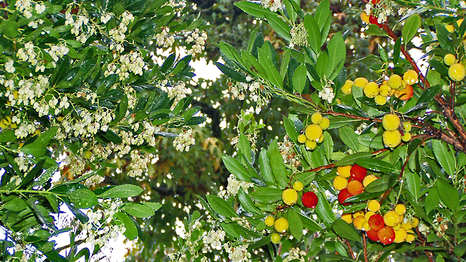
The flowers are shaped like upside-down urns, and are of typical form for the heather family. They are a clear white and are very numerous. They open over a three month Fall period for us, with a few strays towards Spring. The round fruit stays small and green through summer, and not until late in that season do some enlarge and turn yellow and then red. Like the flowers, the fruit mature over a period of months. Both flowering and fruiting can be affected by hard frosts in the northern part of the Strawberry Trees range. In milder zones both can continue into winter.
The plant is evergreen, of medium texture, and grows at a moderate to fast rate. The foliage is a medium green and the bark orange, with the new growth stems sometimes red. It accepts pruning well, and can be handled according to your desired end results. Keep it smaller and shrubby, even hedged, by cutting back strong leaders or even with shearing. If you have room, prune it up and it turns into a nicely gnarled tall shrub. If you open it up in addition, and it can be a airy screen rather than a dense hedge.
This is cold hardy rated from USDA Zones 7 to 9, or down to about zero F. (-18 C). It takes truly hot summers well - tough enough for AHS Heat Zones 3 through 9 (meaning it still thrives with up to 150 days yearly above 86 F. (30C.), or as few as 7. And the drought tolerance is great! Even in the summer-dry American West it does well with little or no water, and in summer wet climates (like the American Eastern Seaboard) it definitely is better without watering.
The botanic name is Arbutus unedo compacta.