On both September 29th and October 3rd a day was spent finding some of the many source founts of the farflung Clackamas River in the high mountain reaches of the Cascades. At 900 square miles, the watershed of the Clackamas includes many forks and tributaries. We located easily accessible sources for both the Oak Grove Fork and the true source of the Clackamas proper. Some of the headwaters are inaccessible with neither road or trails to them, including several on the Warm Springs Indian Reservation.
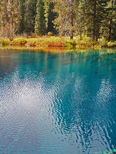
The access route for this trip is Highway 26 over Mount Hood at Summit (Government Camp) to Forest Service Road 42. Many of the vine maples on this stretch are blazing red this time of year. After a few miles of attractive roadside forest, turn right on Forest Service Road 58 for the two mile sidetrip to Little Crater Lake. This startingly bright rich blue pool is the result of a large 34 degree (1.1 degree celsius) artesian spring eroding out soft siltstone. It formed a 45 foot deep cliff-sided basin, which has many toppled trees visible in the clear waters, preserved by the cold temperatures. The lake sits at about 3250 feet (990 m. ) elevation.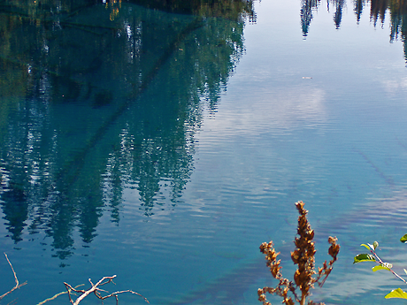
The name results from comparison to Crater Lake. This one isn’t directly the result of volcanism, but the intense blue of the water invites comparison. And early visitors were not always clear about how to discern different geologic processes.
The surrounding terrain is flat and only slightly sloping. Good views of Mount Hood exist to the North. Fall color was good though most of the trees around are conifers. Shrubs provided most of the reds. In spring the meadows are worth a visit just for the wildflowers.
Next stop was the Clackamas Lake Historic Ranger Station, still in use a full hundred years since the location was selected. One structure has been turned into a small museum, and others can be rented for overnight stays. The surviving structures were built starting in the 1933 days of the Civilian Conservation Corps. The earlier structures from as far back as 1906 were built directly on the soil with little regard for longevity, and have all been torn down. The CCC structures were built to last, and the only losses have been to fire.
The 1933 Clackamas Lake District Ranger’s Office is now on the National Registry of Historic Buildings. Currently its the one used as a museum. Staff is helpful, knowledgeable and quite willing to give a talk at the drop of a hat.
A short hike takes one to Clackamas Lake and the springs that feed it. It is about 3400 feet (1036 m.) in elevation.

The lake is an unusual shade of blue, more of a clear teal really. This is due to a rare species of algae known as mares eggs. A wooden walkway extends from the campground out to the edge of the lake. A broad apron of marsh surrounds the lake, inhabited by swamp Engelmann spruce, swamp lodgepole pine, willows and a rare-in-these-parts shrub birch.The several springs are less than a yard ( 1 m.) above the lake, just enough to give a little current to the flow. Likely more springs are submerged. Beavers have cut some conifers at the springs, probably for lack of trees they actually like. A large population of monkey flowers (Mimulus guttatus) grows at the springs, now mostly dried up and gone to seed, but a single plant was green and blooming still.
The lake trail continues on in a loop through meadows and a tract of old growth. More 1930’s Forest Service facilities are included on the two mile (1.21 km.) loop. A longer loop for all day outings can take in all of Timothy Lake as well. Both loops follow the Pacific Crest Trail on parts.
Huckleberries provide much of the fall color in this section of the Mountains, as this scene along Miller trail attests. Some species are red, others purple and still others yellow, and sometimes all three can be found intermingled.
Next in line is Summit Lake, down a one mile section of gravel road (USFS Road 151), recently upgraded to good condition by filling in the sizable potholes. A campground lines some of the far side of the lake. 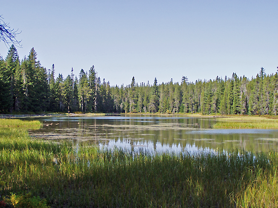 The Forest Service maps show a creek entering and exiting this lake, but no sign of flow in or out exist. Low points exist at either end, but no active channels are present.
This is a higher elevation lake than those mentioned above at about 4200 feet (1280 m.). Pacific silver fir and mountain hemlock are two species not seen previously at the lower elevation sites. Dragonflys were still mating despite the late season, soon to be freezing and collecting snow at this elevation. I’ve skied at the end of October in an early storm. Today for us it was shirtsleeve weather.
Continuing down Forest Service Road 42 it is nearly ten miles (16 km) to Forest Service Road 4220. Here someone wisely painted on the asphalt the road numbers, as the signs have disappeared too many times. A sharp left to the south, one that would easily be missed, is called for. Another 8 miles or so brings you to the glaciated lakes region of the Olallie Highlands. Here meadows, lakes and trails abound, overlooked by 7215 foot Olallie Butte.
First stop here was for a brief view of Olallie Meadows, an extensive probable former lake area bisected by the boundary of the Warm Springs Indian Reservation. A campground exists on the Forest Service side, along with an old cabin. A trail oto Reservation land reaches three high elevation lakes, and intersects with the Pacific Crest Trail.
Next stopping at Lower Lake Campground, we hiked down to the lake. It is a 1.25 mile (2 km) walk with less than a 200 foot (60 m) elevation change. The stony-floored high elevation mixed forest is open at this 4800 foot (1460 m) site. There are good views of the shallow lake as the trail passes on the North side. At the far end of the lake junctions with more trails provide access to more lakes in three directions. A short distance left of the trail is the bouldered outlet of the lake, dry this time of year but with obvious signs of flow earlier in the season. Looking back East across the length of this glacial lake is a surprise hidden until this point - Olallie Butte, looming 2500 feet higher only two miles distant.
Just a little way up the road is Head Lake, the highest source of the Clackamas tributary Squirrel Creek at about 5000 feet (1525 m.). Scenic, rockstrewn, and right on the road, this is a nice one. A small ridge separates it from Olallie Lake and streams that flow off to dry Eastern Oregon. The Pacific Crest Trail crosses the road along this ridge, one of the Trails closest passages of a resort. Over a mile long, this is the largest lake in the Olallie Highlands. The resort and its store were still active, offering rental boats, cold drinks, food and lodging. Olallie Lake Resort is well worth a visit for the rustic lakeside cabins and many recreational opportunities. Horseback riding, fishing for the oversized rainbow trout, even mountaineering in nearby Mount Jefferson Wilderness Area are among the attractions. The resort is open mid-June nearly to the end of October. Unfortunately the new owners did not see fit to keep the resort open in winter. Previously you could ski in across prepared tracks or ride in on snowcats for a winter stay. At this elevation snow is practically guaranteed November through May.
On the second trip returned home via Forest Service Road 46, known locally as Berry Creek. Making a loop of the whole trip, we travel down the mainstem of the Clackamas. However, on the first trip, we continued south to the highest lakes easily visited in the Cascades.
‘Easily’ of course is relative and only means you can drive the road in a vehicle with high road clearance and tough tires. Low slung vehicles should not attempt this route down 4220 much past Olallie Lake. And if you don’t cotton to dodging potholes, ruts and boulders next to precipices, perhaps this is not your route. But 5500 foot (1675 m.) elevation Breitenbush Lake and its campground is your reward for the attempt, along with access to a collection of lakes and flowering meadows at yet higher elevations. This is one of the few areas in Oregon where you can visit alpine meadows not on a major glaciated peak.
Following the 4220 downhill after the lake is not quite so rough. Watch for a wide pulloff on the left; an unmarked trail leads to a rarely visited waterfall. This road follows a wide bench in the middle of a long slope, rising to 4800 ft above and dropping to 3000 ft below the road. When you strike pavement, turn right to return to the Portland area via the Berry Creek route FS Road 46. A left heads you towards Salem.
Sunday, October 08, 2006
Clackamas Headwaters Tour
Saturday, October 07, 2006
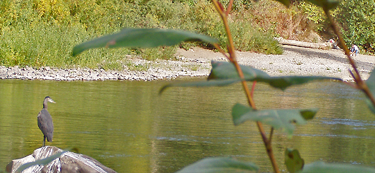
Great Blue Herons
These large predators are frequent visitors here, but the fishermen and others along the river keep them from becoming resident long term. Their harsh guttural squawks can be heard at any time of the night or day. Always solitary in daily life, they surprise everyone by nesting in large clusters of huge nests, from 8 to 170 in a single tree or group of adjacent trees near water.
Last spring we observed a pair flying together or following one another several times, which is unusual. 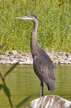
These herons are 'great' due to their size - a wingspan up to 6 feet (1.8 meters) and a height of 42 inches (1.4 meters). Three-quarters of their diet is fish, and are indeed usually seen fishing in rivers and lakes. Great Blue Herons also grab crawdads, insects and frogs. They will hunt in fields for rodents and reptiles. They round out their diet with a small amount of plant materials.
They also adore koi and goldfish in home decorative pools; protective netting may be required if a pond attracts Great Blues. I witnessed one who took up residence near a wealthy man's lakeside estate, where several very fancy koi were kept in a very expensive Japanese-style pond complex. Both he and his butler were fascinated with the huge bird landing in the big firs around the neighborhood. Then some $250 koi went missing, and it wasn't until the pond maintenance workers put two and two together that the mystery of the missing fish was solved.
Great Blue Heron range widely - across the continent, into the high Cascade Mountain lakes, down to the Gulf Coast, Mexico and well into Canada and southern Alaska.