On both September 29th and October 3rd a day was spent finding some of the many source founts of the farflung Clackamas River in the high mountain reaches of the Cascades. At 900 square miles, the watershed of the Clackamas includes many forks and tributaries. We located easily accessible sources for both the Oak Grove Fork and the true source of the Clackamas proper. Some of the headwaters are inaccessible with neither road or trails to them, including several on the Warm Springs Indian Reservation.
The access route for this trip is Highway 26 over Mount Hood at Summit (Government Camp) to Forest Service Road 42. Many of the vine maples on this stretch are blazing red this time of year. After a few miles of attractive roadside forest, turn right on Forest Service Road 58 for the two mile sidetrip to Little Crater Lake. This startingly bright rich blue pool is the result of a large 34 degree (1.1 degree celsius) artesian spring eroding out soft siltstone. It formed a 45 foot deep cliff-sided basin, which has many toppled trees visible in the clear waters, preserved by the cold temperatures. The lake sits at about 3250 feet (990 m. ) elevation.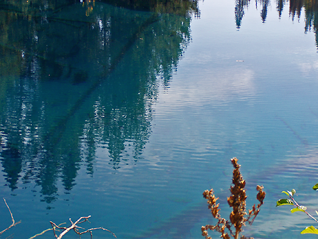
The name results from comparison to Crater Lake. This one isn’t directly the result of volcanism, but the intense blue of the water invites comparison. And early visitors were not always clear about how to discern different geologic processes.
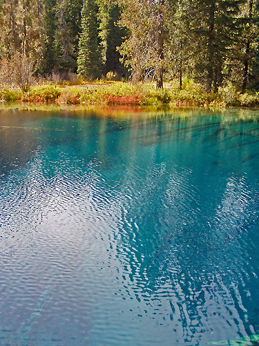
The surrounding terrain is flat and only slightly sloping. Good views of Mount Hood exist to the North. Fall color was good though most of the trees around are conifers. Shrubs provided most of the reds. In spring the meadows are worth a visit just for the wildflowers.
Next stop was the Clackamas Lake Historic Ranger Station, still in use a full hundred years since the location was selected. One structure has been turned into a small museum, and others can be rented for overnight stays. The surviving structures were built starting in the 1933 days of the Civilian Conservation Corps. The earlier structures from as far back as 1906 were built directly on the soil with little regard for longevity, and have all been torn down. The CCC structures were built to last, and the only losses have been to fire.
The 1933 Clackamas Lake District Ranger’s Office is now on the National Registry of Historic Buildings. Currently its the one used as a museum. Staff is helpful, knowledgeable and quite willing to give a talk at the drop of a hat.
A short hike takes one to Clackamas Lake and the springs that feed it. It is about 3400 feet (1036 m.) in elevation.

The lake is an unusual shade of blue, more of a clear teal really. This is due to a rare species of algae known as mares eggs. A wooden walkway extends from the campground out to the edge of the lake. A broad apron of marsh surrounds the lake, inhabited by swamp Engelmann spruce, swamp lodgepole pine, willows and a rare-in-these-parts shrub birch.The several springs are less than a yard ( 1 m.) above the lake, just enough to give a little current to the flow. Likely more springs are submerged. Beavers have cut some conifers at the springs, probably for lack of trees they actually like. A large population of monkey flowers (Mimulus guttatus) grows at the springs, now mostly dried up and gone to seed, but a single plant was green and blooming still.
The lake trail continues on in a loop through meadows and a tract of old growth. More 1930’s Forest Service facilities are included on the two mile (1.21 km.) loop. A longer loop for all day outings can take in all of Timothy Lake as well. Both loops follow the Pacific Crest Trail on parts.
Huckleberries provide much of the fall color in this section of the Mountains, as this scene along Miller trail attests. Some species are red, others purple and still others yellow, and sometimes all three can be found intermingled.
Next in line is Summit Lake, down a one mile section of gravel road (USFS Road 151), recently upgraded to good condition by filling in the sizable potholes. A campground lines some of the far side of the lake. 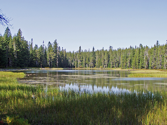 The Forest Service maps show a creek entering and exiting this lake, but no sign of flow in or out exist. Low points exist at either end, but no active channels are present.
This is a higher elevation lake than those mentioned above at about 4200 feet (1280 m.). Pacific silver fir and mountain hemlock are two species not seen previously at the lower elevation sites. Dragonflys were still mating despite the late season, soon to be freezing and collecting snow at this elevation. I’ve skied at the end of October in an early storm. Today for us it was shirtsleeve weather.
Continuing down Forest Service Road 42 it is nearly ten miles (16 km) to Forest Service Road 4220. Here someone wisely painted on the asphalt the road numbers, as the signs have disappeared too many times. A sharp left to the south, one that would easily be missed, is called for. Another 8 miles or so brings you to the glaciated lakes region of the Olallie Highlands. Here meadows, lakes and trails abound, overlooked by 7215 foot Olallie Butte.
First stop here was for a brief view of Olallie Meadows, an extensive probable former lake area bisected by the boundary of the Warm Springs Indian Reservation. A campground exists on the Forest Service side, along with an old cabin. A trail oto Reservation land reaches three high elevation lakes, and intersects with the Pacific Crest Trail.
Next stopping at Lower Lake Campground, we hiked down to the lake. It is a 1.25 mile (2 km) walk with less than a 200 foot (60 m) elevation change. The stony-floored high elevation mixed forest is open at this 4800 foot (1460 m) site. There are good views of the shallow lake as the trail passes on the North side. At the far end of the lake junctions with more trails provide access to more lakes in three directions. A short distance left of the trail is the bouldered outlet of the lake, dry this time of year but with obvious signs of flow earlier in the season. Looking back East across the length of this glacial lake is a surprise hidden until this point - Olallie Butte, looming 2500 feet higher only two miles distant.
Just a little way up the road is Head Lake, the highest source of the Clackamas tributary Squirrel Creek at about 5000 feet (1525 m.). Scenic, rockstrewn, and right on the road, this is a nice one. A small ridge separates it from Olallie Lake and streams that flow off to dry Eastern Oregon. The Pacific Crest Trail crosses the road along this ridge, one of the Trails closest passages of a resort. Over a mile long, this is the largest lake in the Olallie Highlands. The resort and its store were still active, offering rental boats, cold drinks, food and lodging. Olallie Lake Resort is well worth a visit for the rustic lakeside cabins and many recreational opportunities. Horseback riding, fishing for the oversized rainbow trout, even mountaineering in nearby Mount Jefferson Wilderness Area are among the attractions. The resort is open mid-June nearly to the end of October. Unfortunately the new owners did not see fit to keep the resort open in winter. Previously you could ski in across prepared tracks or ride in on snowcats for a winter stay. At this elevation snow is practically guaranteed November through May.
On the second trip returned home via Forest Service Road 46, known locally as Berry Creek. Making a loop of the whole trip, we travel down the mainstem of the Clackamas. However, on the first trip, we continued south to the highest lakes easily visited in the Cascades.
‘Easily’ of course is relative and only means you can drive the road in a vehicle with high road clearance and tough tires. Low slung vehicles should not attempt this route down 4220 much past Olallie Lake. And if you don’t cotton to dodging potholes, ruts and boulders next to precipices, perhaps this is not your route. But 5500 foot (1675 m.) elevation Breitenbush Lake and its campground is your reward for the attempt, along with access to a collection of lakes and flowering meadows at yet higher elevations. This is one of the few areas in Oregon where you can visit alpine meadows not on a major glaciated peak.
Following the 4220 downhill after the lake is not quite so rough. Watch for a wide pulloff on the left; an unmarked trail leads to a rarely visited waterfall. This road follows a wide bench in the middle of a long slope, rising to 4800 ft above and dropping to 3000 ft below the road. When you strike pavement, turn right to return to the Portland area via the Berry Creek route FS Road 46. A left heads you towards Salem.
Sunday, October 08, 2006
Clackamas Headwaters Tour

Saturday, October 07, 2006
Great Blue Herons
These large predators are frequent visitors here, but the fishermen and others along the river keep them from becoming resident long term. Their harsh guttural squawks can be heard at any time of the night or day. Always solitary in daily life, they surprise everyone by nesting in large clusters of huge nests, from 8 to 170 in a single tree or group of adjacent trees near water.
Last spring we observed a pair flying together or following one another several times, which is unusual. 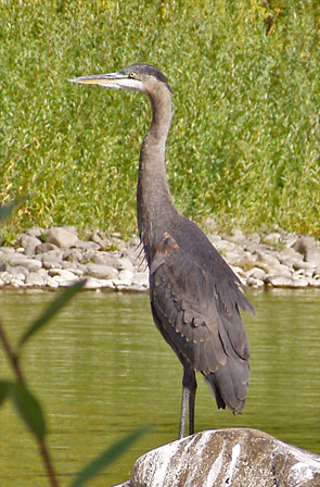
These herons are 'great' due to their size - a wingspan up to 6 feet (1.8 meters) and a height of 42 inches (1.4 meters). Three-quarters of their diet is fish, and are indeed usually seen fishing in rivers and lakes. Great Blue Herons also grab crawdads, insects and frogs. They will hunt in fields for rodents and reptiles. They round out their diet with a small amount of plant materials.
They also adore koi and goldfish in home decorative pools; protective netting may be required if a pond attracts Great Blues. I witnessed one who took up residence near a wealthy man's lakeside estate, where several very fancy koi were kept in a very expensive Japanese-style pond complex. Both he and his butler were fascinated with the huge bird landing in the big firs around the neighborhood. Then some $250 koi went missing, and it wasn't until the pond maintenance workers put two and two together that the mystery of the missing fish was solved.
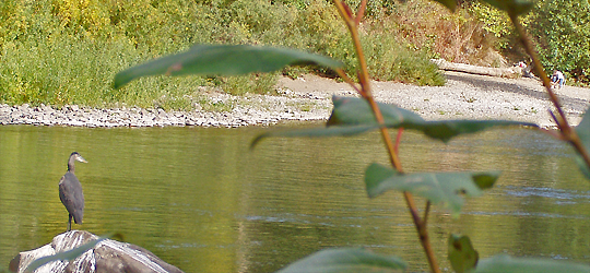
Great Blue Heron range widely - across the continent, into the high Cascade Mountain lakes, down to the Gulf Coast, Mexico and well into Canada and southern Alaska.
Monday, September 25, 2006
Down The River Cleanup
September 10th was the date for the Down The River cleanup. Thirteen miles of heavily used Clackamas River received its fourth annual cleanup from 251 volunteers, counting only those who took to canoes, rafts, driftboats, catarafts, kayaks and one inflatable whale. 5.27 tons of trash was hauled out, more than double the previous record from last year. Another 30 or so folks were busy with behind the scenes work, including preping for the free cookout that followed.
After the obligatory mass form filling, the volunteers were divided into 15 groups, each with an assigned stretch of riverfront. The orientation session was huge! Each group included a large inflatable acting as garbage scow. Some brought their own vessels, while others jumped into rafts and other craft provided for the boatless. Multiple launchpoints were used. Participants varied from teenagers to those in their 60's, from eager and inexperienced to professional kayakers and seasoned river guides. 18 members of the Oregon National guard cooperated with the Clackamas County Dive/Rescue Team and pulled out deep water trash the rest of us would have never known existed. Everyone enthusiastically hunted down errant garbage and were proud to help out!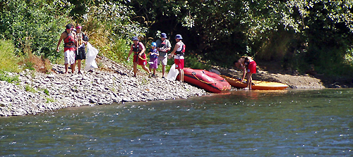
The largest contributor to the record haul was a seven-foot tire from some unknown piece of heavy equipment. The leading theory is that its been heading downstream since the 1996 floods from a gravel quarry which was washed out that year. Guesstimates of its weight settled on half a ton. The large plastic garbage bags provided for cleanup were inflated, stuffed inside the mammoth tire, and it became a raft for its mile and a half journey to Clackamette Park! It was turned on edge and muscled up the boatramp and amazingly enough right into a waiting dumpster. 
Other trash included dentures, eroded stuffed animals, chromed sections of railroad rails (great paper weights), two couches, a prom picture, collapsed rubber rafts, and a hot water heater. Everything possible was sorted and recycled. This event is truly a group effort, with nearly 300 individuals and 26 organization lending their support.
The two primary groups behind the effort are The Clackamas River Basin Council and eNRG Kayaking. The list of others lending support is long:
Next Adventure (food for the barbeque), Portland State University Outdoor Recreation Program (organizational direction for the river crews), All Star Rafting, Oregon Kayak and Canoe Club, Clackamas County Parks, Clackamas County Dive/Rescue Team (getting all that trash unseeable except to divers), Oregon National Guard, Clackamas County Solid Waste and Recycling (FREE dumpsters), the NW Rafters Association, Metro, Stop Oregon Litter and Vandalism, New Seasons Market (food for the Barbeque), Noah's Bagels, Clif Bar (free energy bars), Patagonia (auction items), NRS, Mississippi Studios (free entertainment at the barbeque), Keen Footwear (auction items), Oregon Whitewater Rafters Association, American Medical Response(Medical personel fortunately not needed as such), Hi-Tek Scuba (auction items), the Oregon Watershed Enhancement Board, Wet Planet, and Alder Creek Canoe and Kayak. Many of the outdoors groups provided group leaders.
The efforts of public-spirited outdoors groups, local businesses, governmental agencies, and conservation groups combine to make this one of the most sucessful and effective public volunteer efforts in the country.
Sunday, September 17, 2006
Snow already on Mount Hood!
Several inches of snow fell at Timberline Lodge on Mount Hood last week, and a few more inches are forecast for tomorrow. Flakes fell as low as 3500 ft (1070 m.). This is early, and the newscasts on TV showed folks out on their boards (scratches guaranteed!). Early for serious cross-country skiing is the end of October, with mid-November normal. I'll vote for early - but this early snow is no guarantee of that!
Thursday, September 14, 2006
The Big Drawdown
Observing feeding rates at your bird-feeders will give you some good information about your ‘clients’ or ‘customers’ - your backyard birds. We have two thistle feeders for the bright goldfinches and two more with a sunflower/cracked corn/millet/etc. mix that provides for red-headed house-finches, wrens, towhees, parasitic cowbirds, chickadees and others.

Of course feeding is strong and continuous all during the nesting process. Food must be brought to the nest sitter and so the more vivid males are seen more frequently than their mates. This all becomes ‘normal’ spring into summer.
The first ‘Big Drawdown’ comes when the young fledge and are brought to the feeders by the parents. After a visual diet of bright yellow male birds, the light gray young remind you of going back to a black and white TV after your color set goes out. The young have the same color patterning as the adults, just in blacks and grays. The young male goldfinches have the same black facial mask, and otherwise they would be hard to distinguish from other species of young birds! The rapidly-growing broods come knowing how to eat, and the seed levels drop quickly.
The second ‘Big Drawdown’ isn’t from the increasing population of birds, but from a more hidden force. The same young and their parents come, but the seed levels in the feeders again drop at an accelerated rate. Instinct tells young and old alike to prepare for the big migration South. I’ve never seen a truly overweight wild bird, but its certainly not from a lack of trying! This spurt of feeding came about the 20th of August this year, and continues a month later.
Sunday, September 03, 2006
Osprey
We are still hearing the high pitched calls of Osprey, and see them landing on their favorite perches both sides of the river. Osprey live exclusively by fishing. They watch and wait on riverside perches quite a bit and also hover over the water just in case a fish resurfaces. The dives are spectacular and swift - they wouldn't catch many fish otherwise. They hit the water talons first and can go completely underwater. A young one this season was a hesitant diver - and it showed in his results. We estimate that most osprey are successful about one out of three dives. This youngster would stop at the beginning of his dive before finally heading down, by which time the fish, unaware of the osprey, would dive and escape the subsequent impact of the young osprey.

Our section of river is being shared by two pair of osprey this year. One pair nests in a cell phone tower a few miles West next to The Nature Conservancy’s Camassia Natural Area, while the others fly off upstream to points unknown. Male osprey do all the fishing during incubation and brooding. We can observe the birds much of each day during this period. Once the young are fledged, the adults seem to vary their hunting locations more, and are no longer present daily on our waterfront. The chicks are mature in 7 to 8 weeks, increasing over 30 times in size from hatching.
A major limiting factor for osprey is the availability of nesting sites. If all the good sites are already in use, then younger osprey may have to wait years to begin breeding. Why not erect a artificial ‘tree’ with a platform to encourage nesting? We have been asking ourselves this question for years! This has been done elsewhere, and its time to look into it seriously.
There are four subspecies of Osprey in the world. The American and Eurasian forms migrate, while the Caribbean and Australian forms stay year round in the mild climates they inhabit. Some Mexican and Florida populations also do not migrate. The wingspan can exceed 5.5 ft. (170 cm). Northern populations are larger than tropical non-migrant ones, and the females are much larger than the males. The smallest females are the size of the largest males. The biggest birds weigh in at 4.4 pounds (2 kilograms).
Friday, September 01, 2006
Hummingbird Flower
The Hummingbird Flower’ is a welcome addition to our garden. We acquired 5 of them in 1 gallon cans last year, spaced them about 2.5 ft. apart. They filled in well in two months. They’ve blossomed prolifically since just after planting in early July. Heaviest bloom comes in late summer and into Fall. The sprawling growth is thick enough to keep out most weeds, even in its first season. Its drought tolerance is evident too, as our sporadic waterings here in the summer-dry Pacific Northwest has stressed some other new plants but not this one! 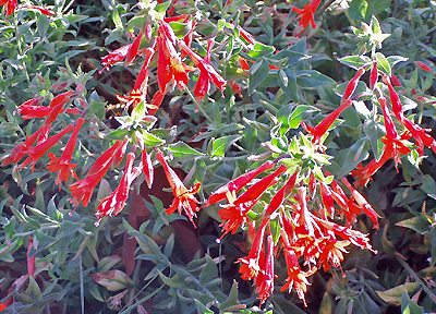

Hummingbirds are commonly said to love this plant, however that is not the case here. I’ve seen them occasionally checking them out, but they much prefer Cape Fuchsia or even Jupiters Beard! Perhaps the cats dissuade them from feeding fron the low flowers.
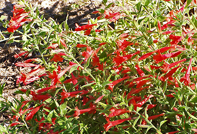
This selected form was originally found by David Salman of High Country Gardens in Santa Fe. It won the 2001 Plant Select award. Its native to the Rockies and other mountains from north Texas to Wyoming. It is hardy to USDA zone 5-9, borderline in Zone 4. Less than a foot high, it can spread over time to several feet across, rooting as it goes. 
We have growing elsewhere the pink form of California Hummingbird flowers,Zauschneria californica “Solidarity Pink”, the California Hummingbird Flower which is perhaps more drought tolerant than garrettii. However, its flowering season starts a little later. Some of it has never been watered this year, especially the largest patch growing in the roadside gravel. Its growth habit is very similar to “Orange Carpet”. The two colors don't mix well in the landscape, but there are plenty of flowers that will. They do make a good groundcover under or in front of medium to tallish perennials like penstemons, lilies or some of the daisies. Blues or purples can mix well with either of these two, and the orange can handle yellows as well. 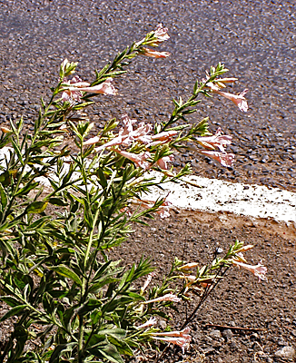
In hotter climates than ours, like the Southern California desert or parts of the Old Southwest, shade is recommended for both species. If you are up North, give it sun, but down South consider at least some shade. In hot dry locations, shade is a must. Some water helps it keep blooming, especially in hot dry gardens.
Botanists have reclassified all Zauchnerias as Epilobiums, or as a type of fireweed. These changes will be slow to make it to gardening circles, as from a landscape standpoint fireweed and hummingbird flowers are distinct. The original Zauschneria garrettii ‘Orange Carpet’ is correctly according to the botanists Epilobium canum spp. garrettii ‘Orange Carpet’, while Z. californica is now E. canum spp. canum. You will see many sources using the form cana, which correctly matches Latin gender for Zauchneria, but to match Epilobium use canum.
John Muir mentions passing large patches of Zauchneria while heading towards Black Mountain Glacier near Yosemite in his 1888 book titled “Picturesque California”. Old references like this are the main reason for remembering superseded botanical names.
Sunday, August 27, 2006
Stargazer Lily
This bright red has about as much impact as any lily out there. The color is far from understated, and the wide blossoms face you, not downward like so many lilies, It fact it was named this because the blooms face the sky. The fragrance is concentrated and wide-ranging. It opens in early August here in Western Oregon; for you the exact time will vary with your climate, as soon as early July in hot Southern areas and late August up North.

Here in our garden it grows a sturdy 5 ft. tall, so its easy to nose up to for the fragrance. Ours are not in the best of soils but are increasing and blooming well. There have been no pest problems at all. Like most lilies, give it sun and good drainage. Some gardeners in the South think its better in shade to preserve the flower color, so the general rule is more sun to the North, and more shade to the South. It needs no staking. Deadhead to get more plant energy into a bigger plant for next year. It grows well in Zones 4 to 9, taking temps down to -25 fF (-32 C).
Be careful to verify you are really getting the true Stargazer - reports indicate some nurserymen may be substituting other less popular lilies for this one.
Thursday, August 24, 2006
Canada Geese
We sighted the first large Fall flock of Canada Geese this morning. About 20 silent birds flew low directly over the river, in a ragged lopsided V. This is early for this.
Several pairs raised their young on the Clackamas behind our house. The numbers in each clutch were large but constantly diminishing. These birds mate for life. The growth rate of the little ones is astonishing - they reach near adult size in as little as 40 days.
They flock and float together most of the year in large groups, but at nesting time the pairs find isolated nesting sites away from other geese. This is just the opposite of the habits of the Great Blue Heron.
On of the most interesting places to observe these sizable birds is at Chatauqua Park in Boulder, Colorado. A large number of Canada Geese rest overnight on the sloping mown grass park site. They are quite used to people and you can get fairly close to them. Early in the morning they fly to open water elsewhere. The birds take off one or a few at a time and just be careful to duck!
Saturday, August 12, 2006
Bull of the Woods
The Clackamas River Basin Council sponsored an outing to 5523 ft (1683 m.) Bull of the Woods on July 15th.. Located on a watershed between various forks of the Collawash River, the Southwesternmost branch of the far-flung Clackamas,this mountaintop has a rare WWII vintage fire lookout, which is undergoing restoration. Formerly it was rented out by the Forest Service, and hopefully it will be available again. The 6.5 mile roundtrip follows a ridge with periodic views and alternating sections of forest, patches of flowery meadow, and rocky outcrops covered in natural rock-gardens. Diversity of habitat like this gives a wide range of flowers and shrubs, and additionally this locale is the westernmost outpost for some plants from the dry East Slope of the Cascades.
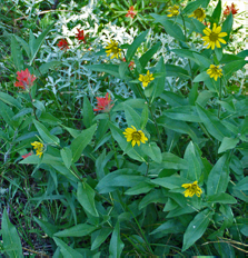
The little sunflower (shown here with Indian Paintbrush) is widespread to the East but confined here to dry meadow habitats and sometimes thin, rocky soils.
Washington Lily is common along the trail, and its strong delightful fragrance was picked up sometimes before that sight of the large white trumpets.
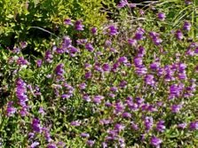 The Penstemon group embraces both evergreen shrublets and herbaceous perennials. Many of them are eminently gardenable. A rock garden type is Cardwell’s penstemon, an evergreen groundcover shrublet. It prefers sun and dry conditions, even growing from fractures in rock and road cut subsoils. The botanists tell us that some of the plants here may be actually Davidson’s penstemon instead. This is a lower growing, fewer flowered, more easterly species, but the two are so similar that many experts suspect they intergrade. Walking this trail one can observe both shorter plants with one-sided flower spikes, and taller, lusher looking ones like the one pictured with ’less distinctly one-sided flower spikes’. Cardwell’s penstemon grows well in the city and is a good choice for dry situations. Don’t try in on heavy clay. The blooming season is short but spectacular.
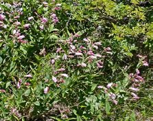
A taller herbaceous type is the woodland turtlehead. Its common throughout mid-elevations of the Cascades most often under trees but we also found it in meadows, like the one pictured here. Its a close offshoot of the Penstemon genus, given the botanic name Nothochelone instead, but most observers would assume its in the Penstemon genus. Plants out in the sunny meadows are more upright and less sprawling, and have a few more flowers than the same kind under the shadowy trees.  The widespread pink Pacific Rhododendron was past its flowering season on this outing. However, the less common white Cascades azalea was at its peak.
Friday, August 11, 2006
McNeil Point Travels
Our travels took us August 6th to McNeil Point on Mount Hood in the Mount Hood Wilderness Area. This is a popular high elevation hike with spectacular view of the broad Sandy Glacier and the terrain north and west of the mountain. Wildflowers abound in the open areas, which become common around 6000 ft. (1830 m.) elevation.
Last winters heavy snowfall appears to have at least temporarily reversed the decline of Sandy Glacier, Three years earlier, a large body of water impounded under this glacier broke out in a sudden and devastating jokulhaup outwash event, which removed or buried forests two thousand feet lower in elevation and deposited a thick layer of boulders, stones and glacial grit for miles down the Muddy Fork of the Sandy River.
The first picture, taken in 2003, shows the punctured snout of the Sandy Glacier the summer after the event. Taken with an 8X telephoto, it is somewhat foreshortened. The trees in the apparent foreground (actually half the way from the camera to the glacier) are 50 to 80 ft. high (15 to 25 m.). The opening itself is probably a couple of hundred feet across. An attempt to traverse closer to the glacier in an off-trail route to get a more accurate size estimate of the glacier may be made later this year. 
This hole is huge. It remained open from 2003 through the summer of 2005, or three years. 
In 2006, things were different. Here are side by side a 2003 picture followed by one taken in August of this year.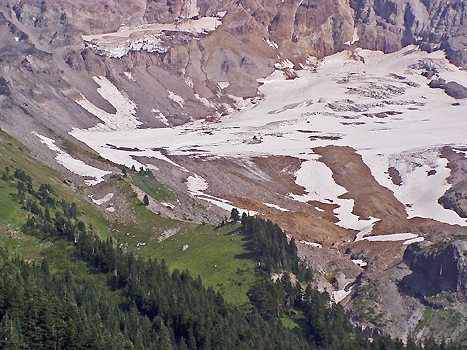
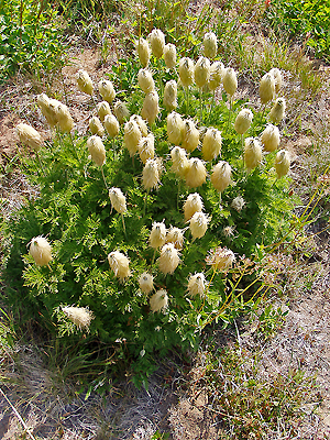
Among the meadow plants we hiked past were the Western Pasque flower, which had reached its interesting seed stage.
At this point in its life cycle it goes by a variety of creative monikers, like old man of the mountain, mouse on a stick, and mousicle. Its has a showy cup-shaped white blossom, early in the mountain spring.
The white mountain heather was in bloom.
Along side it was the red and the greenish-yellow species also. Its unusual to see all three of our heathers together.
Here are two meadow pictures. Meadows are the glory of the heights; these pictured are low in diversity but showy nonetheless. 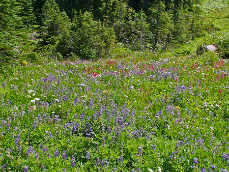
This picture shows a sloped meadow with white valerian, blue lupine and red paintbrush. Other plants are present in small numbers. Distribution zoning is obvious - the red paintbrush forms a visible band running left and right, yet is absent elsewhere where conditions are not the best for it. 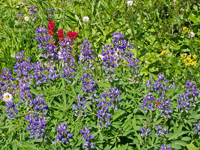
This closeup is dominated by blue lupine, the most adaptable plant up there, with paintbrush, a few scattered pale asters, and a cluster of yellow senecio.
By continuing up McNeil Ridge a hiker can soon leave most of the visitors behind. Another thousand feet up to 7,000 ft (2135 m) are dramatic stone cliffs with wide ranging views. 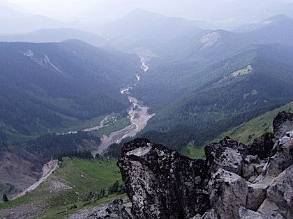 The view down the Muddy Fork of the Sandy River clearly shows the extent of the outwash event. Both branches draining the glacier show a fresh gray gravel channel. The closer fork on the right is much broader, the result of the jokulhaup. The left branch flooded from rapid warming, rain and snowmelt, but no glacial outwash event happened there. Before the event greenery covered most of the lower basin, but large sections of forest and brushfield were erased that Winter. Each sucessive outwash cuts away more of the moraine in the left foreground, depositing it far below. Heavy deposits of outwash material from earlier events extend at least 20 miles (32 km) downstream; the mile-wide Columbia has been moved over by the huge amounts of material carried down the Sandy. Mount Hood had erupted shortly before the 1805 visit of Lewis and Clark, and the amount of material dumped by the Sandy overwhelmed the much larger Columbia. To this day the Columbia bends around the delta of the Sandy in a shallow broad channel.
My ‘parting shot’ was taken partway down the steep face of McNeil Point, looking North at the heavily carved ridge which was long gnawed at by the two tongues of the Sandy Glacier. These days it is beyond the reach of the diminishing glaciers, but erosion from glacial melt-water continues to work away at the base of this ridge.
