Our travels took us August 6th to McNeil Point on Mount Hood in the Mount Hood Wilderness Area. This is a popular high elevation hike with spectacular view of the broad Sandy Glacier and the terrain north and west of the mountain. Wildflowers abound in the open areas, which become common around 6000 ft. (1830 m.) elevation.
Last winters heavy snowfall appears to have at least temporarily reversed the decline of Sandy Glacier, Three years earlier, a large body of water impounded under this glacier broke out in a sudden and devastating jokulhaup outwash event, which removed or buried forests two thousand feet lower in elevation and deposited a thick layer of boulders, stones and glacial grit for miles down the Muddy Fork of the Sandy River.
The first picture, taken in 2003, shows the punctured snout of the Sandy Glacier the summer after the event. Taken with an 8X telephoto, it is somewhat foreshortened. The trees in the apparent foreground (actually half the way from the camera to the glacier) are 50 to 80 ft. high (15 to 25 m.). The opening itself is probably a couple of hundred feet across. An attempt to traverse closer to the glacier in an off-trail route to get a more accurate size estimate of the glacier may be made later this year. 
This hole is huge. It remained open from 2003 through the summer of 2005, or three years. 
In 2006, things were different. Here are side by side a 2003 picture followed by one taken in August of this year.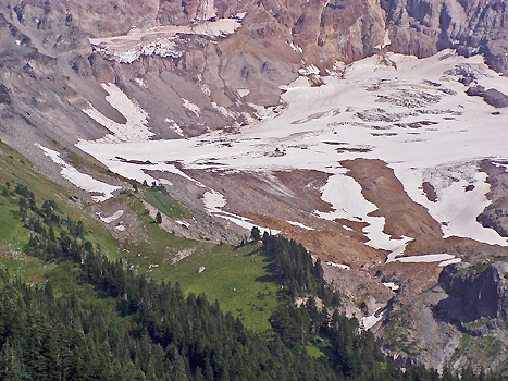
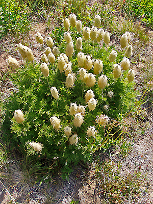
Among the meadow plants we hiked past were the Western Pasque flower, which had reached its interesting seed stage.
At this point in its life cycle it goes by a variety of creative monikers, like old man of the mountain, mouse on a stick, and mousicle. Its has a showy cup-shaped white blossom, early in the mountain spring.
The white mountain heather was in bloom.
Along side it was the red and the greenish-yellow species also. Its unusual to see all three of our heathers together.
Here are two meadow pictures. Meadows are the glory of the heights; these pictured are low in diversity but showy nonetheless. 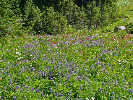
This picture shows a sloped meadow with white valerian, blue lupine and red paintbrush. Other plants are present in small numbers. Distribution zoning is obvious - the red paintbrush forms a visible band running left and right, yet is absent elsewhere where conditions are not the best for it. 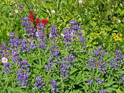
This closeup is dominated by blue lupine, the most adaptable plant up there, with paintbrush, a few scattered pale asters, and a cluster of yellow senecio.
By continuing up McNeil Ridge a hiker can soon leave most of the visitors behind. Another thousand feet up to 7,000 ft (2135 m) are dramatic stone cliffs with wide ranging views.  The view down the Muddy Fork of the Sandy River clearly shows the extent of the outwash event. Both branches draining the glacier show a fresh gray gravel channel. The closer fork on the right is much broader, the result of the jokulhaup. The left branch flooded from rapid warming, rain and snowmelt, but no glacial outwash event happened there. Before the event greenery covered most of the lower basin, but large sections of forest and brushfield were erased that Winter. Each sucessive outwash cuts away more of the moraine in the left foreground, depositing it far below. Heavy deposits of outwash material from earlier events extend at least 20 miles (32 km) downstream; the mile-wide Columbia has been moved over by the huge amounts of material carried down the Sandy. Mount Hood had erupted shortly before the 1805 visit of Lewis and Clark, and the amount of material dumped by the Sandy overwhelmed the much larger Columbia. To this day the Columbia bends around the delta of the Sandy in a shallow broad channel.
My ‘parting shot’ was taken partway down the steep face of McNeil Point, looking North at the heavily carved ridge which was long gnawed at by the two tongues of the Sandy Glacier. These days it is beyond the reach of the diminishing glaciers, but erosion from glacial melt-water continues to work away at the base of this ridge.
Friday, August 11, 2006
McNeil Point Travels
Subscribe to:
Post Comments (Atom)
No comments:
Post a Comment