This perennial flowers like the annual blue forget-me-not but without its weedy ways. Try this perennial forget-me-not to enjoy in a permanent clump-forming foliage plant.
Langtrees Siberian forget-me-not is a hearty grower in most soils as long as some extra moisture is present. It's a wet ground plant rather than a dry forest floor plant. though far from a bog plant. Do expect to water it in summer unless growing in a naturally moist soil or in a region with consistent summer rain. We sited it at the bottom of a slope with some natural seepage through late spring, and it seems to love it. In cool summer areas it will take full sun but in hot regions give it part to full shade. It needs about the same conditions as an astilbe.
The light blue flowers open in airy clusters over the plant late March into May or June with some bloom later. The heart-shaped leaves (up to 8 inches but smaller if dry or in the sun) are lightly variagated silver and remain attractive until winter. Other variations of this species can be more or less variagated, or just green. Expect moderate to fast growth.
If happy it can sprout from seed in places of its own liking. Divide in early spring or fall once it has expanded its rootstock.
In Photo: Brunnera macrophylla "Langtrees"
Heat Hardiness Zones 9 to 3
Cold Hardiness Zones 3 to 7
Height 12-18 inches, 30-45 cm
Spread to 24 inches, 60 cm, or more with age.
Tuesday, May 29, 2007
Siberian Perennial forget-me-not

Saturday, March 31, 2007
Osprey Back
The osprey have returned for the nesting season. Their high pitched call is most distinctive as the mated pairs scout out the 'home territory' they are reclaiming after a South American winter sojourn. In one case we observed a third osprey following the pair - perhaps last year’s offspring. The yearling is likely to find his or her own way before nesting begins in earnest.
We noted osprey last in mid-September. These eagle-sized birds (sometimes mistaken for bald eagles) fish for a living, and will have no other food. Their high-speed dives are easily the most spectacular activity among the wildlife we observe here. They hunt from stream-side perches and by hovering kestrel-like over the river. A guesstimate for their success ratio is about one out of three dives. Sometimes they grasp a large salmon and need to slowly spiral up to gain enough elevation to fly off to their home.
Saturday, March 17, 2007
Mount Talbert In The Snow
The spate of cold weather in January finally brought snowfall for the first time in three years. At our house about four inches fell, enough for me to get out the old Asnes Trends with the crack which I've saved for just such times. An odd combination of high camber racing and metal edged backcountry goodness, they carved christys well, cutting down to the underlying grass only in the turns.
Visiting natural areas in the snow gives you the opportunity to see things that otherwise are always missed. Animal tracks rarely show up in the thick duff of Pacific Coast forests. With fresh snow even a novice tracker will find tracks of several animals, even small ones otherwise never seen.
At Mount Talbert, only two inches were on the ground, not enough for optimum tracking as the larger animals - deer and coyote - will break though the snow, leaving indistinct tracks. A little searching along a track will bring up obvious ones despite this. Smaller animals leave very clear traces in these conditions.
The first track I noticed was rabbit. Following along the track was easy. Soon I found another set of tracks that joined alongside the rabbits - coyote! This fellows interest in the rabbit is strictly gustatory. A second coyote soon joined the track, and the two met, greeting each other, leaving a jumble of tracks - while the rabbit went into a brushpile to hide. No easy meal for the coyotes this time!
Rabbit tracks are round-toed, with the back foot usually leaving a long mark alongside a toes-only front print.
Following other tracks, it became obvious that various animals will use the same path. A open route is open for all. One unidentified large rodent was seemingly accompanied by a deer - but no doubt they were there at different times. The deer passed around fallen trees while the rodent went under.
Following the many deer tracks backwards, I soon found several beds, including these two where they laid during the snowstorm, keeping the ground bare in a curled-up deer pattern. Some of the leaves which was the cushion were shaken off when the deer awoke and lay on top of the fresh white snow. A second, smaller bed was a few yards off, and the animal had evidently slept with one leg stuck out. A third bed was found which was used the night after the snow had fallen. 


Raccoon
Raccoons left clear tracks under these conditions. The front and back tracks are placed along side one another with the back print larger. Like us, raccoons are omnivores, eating meat, fruit, and eggs, and prefer to wash their food well. They are urbanizing well, needing only a small area of cover.

Squirrel
Some squirrel species have a Latin name that means "seed loving", and this describes their feeding habits well. Both ground and tree dwelling types exist, and ours are tree types locally. They spend some time foraging on the ground and so left tracks during this snow event. The elongated toes are adapted for grasping and climbing. In summer they busy themselves cutting conifer cones, dropping them to the ground and then hunting them up on the ground. Many are stored for winter; they will also gorge on the seeds, leaving the dismembered cone scales in sometimes large piles. These are usually near the base of a large fir, their escape route in case of danger. 
Squirrel feeding at Mount Talbert
Monday, February 19, 2007
Lenten Rose
Year-round, lenten rose offers deep green glossy foliage, and better yet it blooms in winter, with a season from February well into April. Its especially welcome on a garden walk on a fine winters day, but be sure to place it where your windows look out upon it for those not so nice late winter days!
These evergreen perennials keep their foliage nice year round, with the previous years laying down as the new greenery comes out in early spring. There it is easily removed to tidy up. The foliage is bold, palmately divided, and is well and thickly presented on a foot or 16 inch-(30 - 40 cm) high mounded plant. The blossoms are rounded, nodding, with a central boss of yellow stamens, and range in color from pure white to very deep red-purple. They stand a few inches higher than the foliage. Often the lighter colors are interestingly spotted, like the clone "White Lady" pictured just below. 
The availability of these plants has greatly improved from years past, with both named clones and improved seed strains now on the market. Some include the blood of multiple species of Helleborus, but often H. orientalis is the predominate type. A sister clone to the above is "Red Lady". Other clones in the catalogs include "Rose Madder", "Heronswood Yellow" "Slaty", "Blue Lady" (actually more of a violet), and "Red Mountain". Seed strains include 'Early Purple', 'Party Dress' and 'Border Mix'. You no doubt can find more!
Above: Naturalized Lenten Rose at Elk Rock Gardens.
The blanket advice often given that these are exclusively shade plants isn't fully correct except in hot climates. They are indeed shade tolerant, but they are also take more sun than they are usually given credit for. Plant them in mostly sunny spots or in shady ones, they will grow well and bloom well either way. Try them under or around taller shrubs too. Quickest growth will result if watered, but as natives of dry summer Mediterranean climates they are very drought resistant.
Making more: These can self-sow and naturalize, and if you wish to sow seed simply collect it in early summer and plant outdoors in loose well-drained soil high in organics. Under outdoor conditions seedlings appear in late spring. Division is possible but the plants are slow to get going again. The plants don't really require dividing and can be left alone indefinitely unless outgrowing their spot. 
Heat Hardiness Zones 9 through 1
Cold Hardiness Zones 4 through 9
Height to 16 - 18 in. (00 - 46 cm) in flower, 12 - 16 in. (30 - 40 cm) foliage mound.
Spreads 24 to 36 inches (30 - 90 cm) or more in time.
Botanic Name: Helleborus orientalis or hybrids with other closely related species.
Native from Thrace into Asia Minor.
On left: Helleborus orientalis "Red Lady"
Tuesday, February 13, 2007
Dragon Wings Begonias
Its rare that something hits the horticultural world that is something truly new, something that was not there before. Plants, after all, have been on this planet almost since the beginning. Now a cross between the common wax begonia and the well-known angelwing begonia has resulted in a series of plants that do things no plant did before.
By combining only the best of traits from the two parents, new possibilities for the garden have arisen. Here we have compact 24-36 inch plants that have large clusters of large bright flowers that produce layer after layer of color on an easily grown, adaptable plant. The picture above is of young plants in the ground only three weeks, from small non-flowering starts. They were planted in early August and the picture was taken on the thirty-first of that month. The plants have the sizable flower clusters of angelwing begonias, but produced with the frequency of the few-flowered clusters of wax begonias, not the sporadic widely spaced way of the angelwing side. The flowers are sterile, so flowering never stops and the old clusters drop off on their own. The leaf size is medium, and a waxy dark green substantial type like the wax begonia. The leaves tell you when the plant needs fertilizer by turning a purple shade.
The flowers dangle so they can be used in hanging baskets. They also display well in beds, and are a real improvement over wax begonias in impact. And they thrive indoors too! These begonias adapt well to the hot steamy conditions down South, and take to cooler summer areas also. Reports from the dry Southwest and California are good too. Some reports indicate they even take light frost, and can survive Zone 8 winters if mulched well. They can be dug and taken indoors for winter, or just grown in pots and shuttled back and forth with the weather.
Our experience is that success indoors is dependent on giving them lots of light. I placed a pair dug from the garden in October in an upstairs bathroom. One had to be behind the other and hence got less light. The one closest to the window has never ceased blooming and growing, while the one getting less light failed completely.
Whenever moving plants inside from the garden, expect some leaf drop from the shock of changing light regimens. All plants vary the structure of its leaves depending on how much light it receives. When a plant is moved from bright outdoor conditions to the comparatively dark indoors, the plant goes into a form of shock, dropping leaves previously adapted to bright light and attempting to grow new ones grown in dimmer light. You can lessen this by choosing shade-grown plants from outside, and then placing them in a sunny window, so that the change in lighting is a little as possible.
You may need to search for Dragon Wing begonias - not all nurserymen have caught on yet to their qualities, and you may have to ask about them or shop around to find them. The seed for them is not only expensive at the wholesale level, but a little more difficult to raise than average. The vigorous young plants fill out small containers rapidly without flowering, so the least expensive small sizes may be offered without blossoms. They bloom well in 4 inch (10 cm) and up pot sizes. Once found in any size, you can put them out as soon as frost danger has past in your area, or use them inside or on protected porches and the like. Their performance will surprise you!
Monday, December 11, 2006
Mount Talbert Nature Park
A new major addtion to the area's urban parks system, this hilltop preserve has a decidedly non-urban look and feel. Mount Talbert is one of many Portland-area peaks resulting from the Boring Volcanics series. A set of trails has now been placed in the park. One circles the mountain, another crosses over the 750 ft. elevation maple and oak covered top, while others fan out to the several trailheads. A notable feature of the park is the undegraded nature of the plant life. Though the trees are young, with the biggest firs only 2 to 3 feet in diameter, there are few invasive non-native plants under the forest canopy, and the natural, native plant associations are still in place.
Here at Mount Talbert, after logging perhaps 60-80 years ago, the trees and native forest floor vegetation was able to return heartily. Low elevation areas with intact natural plant communities are actually unusual, as most of the areas in the valleys and low elevation slopes have been farmed, ranched or urbanized, eliminating the natural ecology. Here land use practices were hands-off for the most part, and the forest had time to recover before the modern-day scourges of Scotch broom, hawthorne and especially Himalayan blackberry were able to intrude and dominate. This gives the park great potential from the educational and research standpoints.
An interesting and worthwhile ecological experiment is underway at the park involving the native Oregon white oak woodlands. This sun loving tree casts a very light shade beneficial to other plants. Douglas-fir seedlings are able to thrive in oak woodlands, but the fir grow 3 to 4 times higher than the oaks, and cast shade too deep for the oaks to tolerate. So in the natural forest succession the oaks will die out. It is thought that the Native American population in this area used fire to improve hunting and for other purposes, which kept the firs from growing, while the thick-barked oaks survived.
The experiment is to favor the oaks artificially by eliminating the competing firs, maples and shrubbery. About 19 acres of oak woodland has been treated in this way, out of 183 acres of parkland here. Firs and other trees in the selected areas have been girdled, topped or cut down, while allowed to continue thriving in the large areas with few or no oaks. This should result in a much more diverse ecology in the park and show us how different the tree cover types will be in terms of understory.

The preservation of Mount Talbert is one of many positive results of the 1995 voter approval of the Metro bond measure dedicated to parks land acquisition in the urban area. We are indeed fortunate to have an electorate wise enough in the long term to see the value of parks in this region. The November approval of a second such bond measure will result in much more parkland purchased and made available in our area.

The 1995 Open Spaces Bond Measure resulted in the purchase of 8146 acres for parks (36% more than the 6000 expected at the time of passage), including 74 miles of stream frontage. This was 263 separate transactions. Its expected that the 2006 measure will directly lead to as much as 5500 more acres, plus this time additional funds for development of parks for public use.
Though good trails are available to the footloose now, the 'Grand Opening' of the park will be next year. Planners have moved the planned primary public entry to a site along Mather Road, with construction in 2007. The original idea of placing the main entry and parking near Sunnyside Road proved impractical upon closer inspection.
Parking has yet to be provided, so autos must be left on residential streets, and signage is limited. Its a challenge to find the trailheads. Once you do, expect a somewhat steep initial climb onto the sides of Mount Talbert, but as soon as the main loop trail is reached, its easy going around the mountain. If you wish more elevation gain, try the Westridge Trail over the top.
Sunday, December 10, 2006
Oaks Bottom Wildlife Preserve Tour
After several visits, here is some commentary on Oaks Bottom, a park and wildlife refuge on the Willamette River in Portland.
Dozens of great blue herons stand in the open, shallow lakes, just far enough apart to be out of beaks reach of each other. The grey color of both the water and the herons made a close look necessary to pick them out. The joggers running by will miss them easily. A single bright white great egret slowly strode across a marshy area, acting no different from the great blues but certainly standing out in the crowd!
A smooth asphalt handicap-accessible path runs North and South from just upstream from here and miles downstream into Portland, ending at the Steel Bridge. The way crosses on a pedestrian path under the bridge and loops through the urban parks of the Portland Waterfront area. This complex of walkways gives Portland a unique combination of urban and nature. It's popular with cyclists, walkers and hikers alike. We brought Grandma in her wheelchair, as nature is one of her few pleasures at 82. Its possible to link this path complex with the more easterly sections of the Springwater rails-to-trails project, bringing several other parks within cycling distance on a day trip. On foot this will take more than one day! The trail section from Oaks Bottom east is funded but yet to be constructed, so a short jaunt on city streets is necessary. To find a route, just drag the Google map to see the streets. The trail crosses 99E on a new bridge near Ochoco Street at about 19th Avenue The trail follows Johnson Creek Blvd for quite a ways, then Foster, eventually ending at Boring. An eventual expansion will follow the old rail line to Estacada, and hence into the Cascade Mountains and the Pacific Crest Trail. So one day it may be possible to start a hike in downtown Portland and end up at the border with Canada or Mexico.
Some unpaved side paths lead to Willamette River views while others circle the lakes and wetlands of the bottoms. More trails link with the Southeast Portland Sellwood neighborhoods. In the pictures here note the skyscrapers of Portland in the background. On the far side against the bluffs wood ducks and the prolific mallards are crowded in their abundance. These ducks seem to prefer being near the small logs blown to this side of the lake. They can use them for perching out of the water yet still be away from shore and its dangers. A single surf scoter was sighted, rare inland from the Pacific and almost never seen in Portland.

Between the marshes and the Willamette River is first a much used railroad track and then the 44 acre (17.8 h.) Oaks Amusement Park. It's been there since 1905. In the 1800's the river connected directly with the bottoms, and the bottoms extended another mile North. The South end became a garbage dump,and the North was largely filled in with debris from freeway construction.
See our earlier Great Blue Heron post
Go to a Google Map of Oaks Bottom Wildlife Preserve. Start at the bottom center of the map, finding the label 'Oaks Pioneer Park'. That park is on top of the riverbank bluff, and Oaks Bottom is below, the brownish area to the north of the label. The Google arial photo was taken during the summer low water.
Friday, December 08, 2006
Winter Jasmine
The first spring blossoms are long weeks away. Even the optimistically-named Christmas rose (Helleborus niger) is still in bud, its touted winter blooms not yet open. Still, an early January walk in the gardens hereabouts will yield a treasure trove of some of the rarest of garden plants - the true winter flowers. Despite the negatives of winter weather - frost, heavy rains, and few if any pollinators active - this season features a hardy few flowers that have chosen it for their preferred time of opening. Winter jasmine is the truest of winter bloomers, opening first in December.
In our garden it begins early in December and is mostly finished flowering by Spring. Though the small leaves drop in Autumn, the stems remain green year-round, giving this shrub the effect of being evergreen. The cheery yellow trumpets are set off by this green backdrop. In full sun flowering can be heavy, and it can grow well in shade. Winter Jasmine is mostly indifferent to soil, doing well in rich or poor as long as drainage is at least fair. The growth habit is exceptional, and is best described as scrambling. In nature is weaves its way between competing shrubs until it finds a suitable spot to grow, and then scrambles some more. In your garden this gives you a plant that cascades well.
Winter jasmines unusual growth habit lends it to special design treatment. It can be used as a groundcover, or a broad low mounded shrub, but its starring role is to be planted where it can cascade down - from atop a wall, in a raised planter, above a slope the steeper the better, or tied to a tall post from which it can arch down. At a local hospital, a planting of winter jasmine cascades down 25 ft. from 2nd and 3rd floor planter boxes. We have this shrub (pictured) falling down a 10 ft. north facing wall. It only took two years to reach the bottom.
Try interplanting this with spreading groundcover roses to get color winter and summer.
Almost all jasmines are fragrant and many winter flowers are too, but winter jasmine is without fragrance.
Generally expect winter jasmine on flat ground to grow loosely to 18-24 inches high with a 10 foot spread. Be prepared for it to root as it goes, so that its potential for spreading is much greater than that of a single plant. For example, the pictured plant in my yard has rooted at the bottom of the wall. Recently rooted stems are easy to remove, to be tossed, transplanted or given away; cutting off the stems before rooting is simple too. If they are let to get well established they become more and more of a project to get out as the years pass!
The closest relative of this plant is forsythia. The two share flower color and shape, early flowering times, the tendency to root at branch tips, and an origin in China. Winter jasmine hails from the provinces of Gansu, Shaanxi, Sichuan, SE Xizang, and NW Yunnan. It is found in thickets often on steep ground, at elevations from 2600 to 15000 ft. (800 to 4500 m). An interesting trait is that this jasmine produces quarter inch (6 mm) berries. It never does so in the West because all plants of winter jasmine originate from a single 1844 introduction - which needs a pollinator which was left behind in China.
Botanic name: Jasminum nudiflorum
Gardening experts seem to differ greatly on the hardiness of this shrub - is it hardy in USDA zones 4 to 8 or 6 to 10 or somewhere in between? The Heat zone range is 1 to 8 or 9. Growth rate is moderate to fast.
Sunday, November 19, 2006
Earthquake!
The Northwest Coast of the US is earthquake prone. Unlike frequently shaken California, here the tectonic forces build up over the centuries until very large quakes occur. Small and medium quakes do occur, but rarely and the stress and strain keeps accumulating. The major quakes may be as large as any on Earth.
The last major quake offshore occurred January 26th 1700, dated by tsunami records fron Japan and tree rings here. The Japanese records of the time state that the waves kept arriving for 18 hours and were up to 10 ft. (3 M.) high. On the Northern California to British Columbia Coasts, blocks of land dropped 15 ft. (4.5m) and more, drowning forests and marshes, which were then covered in coarse sand brought in by a tsunami which took only a few minutes to arrive.
It is thought that the entire length of the Cascadia Subduction Zone lurched in this event - a length up to 685 miles (1100 km.)! Entire Native American villages were rubbed out, and Native tales of the event survived and have been recorded.
Damage nowadays from such a quake could range from California to Canada and would be in the many billions.
A magnitute 5.6 earthquake occurred January 11th 2006 near the Blanco Fracture Trasverse Fault edge of the Juan de Fuca plate 143 miles off the Oregon Coast. Depth of the quake was 6.2 miles (10 km). No tsunami or damage resulted due to the location and size of the quake. This one was small compared to the really big ones of the more distant past.
Cormorants
The first sighting of double-crested cormorants happened this past Friday, November 17. Most cormorants are seabirds, but this one lives and nests inland as well, here in the West as well as on the lakes of the Plains States east down the Great Lakes and St. Lawrence.
These birds are mostly black, goose sized but slender, and up to nearly a yard (9 dm) tall. Weight is up to 5.5 pounds (2.5 kg).These birds swim low on the water, seeming smaller because of this. From the water's surface they leap and then dive into the water to start chasing their fish prey. Surprisingly their feathers are not waterproof. It may be that this makes them less buoyant and faster underwater. They are often seen holding their wings outstretched apparently to dry them. This habit is unique among our local birds, and is no doubt needed without the waterproofing of most diving birds. Two small crests of feathers on the head lead to the name.
We first noticed them about 8 years ago, when they seemed to be strictly winter visitors. This past season they stayed into late Spring. This is one bird whose numbers are increasing, and is actually expanding its range, especially in the Midwest where introduced fish are providing food absent before. Despite much useful habitat for them, they are migrants here.
They seem wary and I haven't gotten a photo yet. As soon as possible a fresh photo or two will be posted.
In ancient times and up into the 1600's it was thought cormorants were a type of raven. The Ancient Greeks called it the bald raven, and the Romans sea raven. In the Germanic languages similar names were originally attached to these birds. Crested kinds were called shags for the topknot, but with the discovery of more species worldwide the distinction and the naming has not held. Indeed one widespread species, the great cormorant, has no crest in Europe but does in Asia.
Thursday, November 09, 2006
Scattered Flooding in Pacfic Northwest
Roads, trailer park gone; other areas escape damage
Days of heavy warm tropical-origin rain has fallen erratically across the Pacific Northwest, with mountain and coastal areas getting far more than the central lowlands. The uneven distribution of the rainfall showed with record flooding on some rivers, and little elsewhere. The Clackamas River rose to levels less than floods of of the past two years. The Willamette and Columbia, the two largest rivers of the region, saw only minor flooding. Elsewhere, especially on mid-sized rivers, the results were catastrophic.
Lee’s Camp, a mobile home park / resort on the Wilson River in the Coast Range mountains, was mostly washed away, with structures never before damaged now destroyed and trailers, some of them primary residences, floating off down the Wilson. This was record flooding. The Sandy River, which originates on Mount Hood, took out houses, and stranded a illegal campful of homeless men who had to be rescued. Higher up the mountain, near Zigzag, the Sandy removed parts of Lolo Pass Road.
Some of the most astounding flood effects came on the White River on the south side of Mount Hood. Like the Sandy, it heads in the glaciers high on the mountain. This makes both rivers subject to glacial outburst floods and generally higher flood levels due to snow and ice melt during these warm rains. Highway 35 at White River is now buried under grit, gravel and boulders of up to ten tons and more. The bridge over the river is still there but is buried and the river is to the east running in a new twenty foot deep channel. Its guesstimated that a million cubic yards of material was on the move in the White River Outwash Plain. The same highway near Pocket Creek Snowpark now has Clark Creek and Newton Creek both running down it. These two washouts has isolated Mount Hood Meadows Ski Resort from the outside world. Highway officials have set up plans for damage assessment but until this is done there is no telling how long repairs will take. Officials are hinting at the need for Federal dollars, which implies yet more time. And with winter snows just beginning, the timing could not be worse.
This is only the most recent of such outwash events at the White River crossing! This is the most rapidly eroding part of Mount Hood, where deep fragmental deposits are easily undercut and moved by the river. The first such event happened over eighty years ago, just a month after the highway first opened. A winter storm - in August! - hit the mountain and gave highway engineers their first taste of rebuilding at this spot. The wooden bridge was gone. Repeats of this occur about once a decade. To view a good source for pictures of this weeks damage from a local TV station, click here. Since this was posted yesterday, a good overview has been posted in a blog connected to Mount Hood Meadows by Dave Riley. Having toured all the washouts with officials, an informed report was possible, and pictures have been promised in the next day or so. Repairs are already underway on the Hood River approach, but the White River side will take more time.
Here is a link to a Google hybrid map of the area. A gray stripe of glacial outwash clearly shows crossing 35 south of Mount Hood, and the road is blocked from there to a point just north of the green arrow. Also to get an impression of the area, try a Google Earth search for "Highway 35, Mount Hood, OR". Rotate 180 degrees and follow highway 35 back. 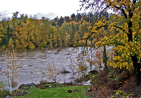
Flooding and Fall Color From Our Location
Elsewhere, the towns of Nehalem and Tillamook on the tourist-dependent Oregon Coast have a good deal of muddy flooding and some road damage. North in Washington State flooding, landslides, and washed away homes were widespread. The elk hunting season was in full swing and an unknown number of sportsmen are cut off by landslides and washed out roads. Official guesstimates are that a thousand are stuck in the woods with their vehicles. As many planned to stay in camp a week, not all are ready to be rescued. Some roads will be fixed quickly. Southern Oregon was out of the main storm path and has seen few problems.
Amid the sensationalism of news reports, remember the scattered nature of the flooding. While some spots did see record water levels, others were far from it and saw little or no damage, even for areas that often flood.
Saturday, November 04, 2006
Rising Waters
Well, The Old Farmers Almanac is correct at the moment. They predicted above average rainfall for our area in early to mid November. After a dry October, we are now getting river-raising levels of rain. Two inches (5 cm) of rain is predicted for Sunday the 4th, and a break is not forecast until Thursday. Another three days of rain will follow! The rains began on the First. 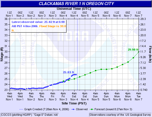 Shown above is the National Weather Service river levels chart of this morning, and the results are clear. Green is predicted river levels and blue actual results. The gauge is located at the South Fork Water Intake just upstream from us. Our levels are perhaps a foot less. If the rate of river level increase holds until Friday, which is possible but not guaranteed, then a higher than average flood is on its way.
The gauge was installed in 2002, so our figures for the earlier floods are approximate. 1996 saw the three highest flood levels in our time here. The highest was about 12 ft. (3 m.) above 'average' winter high water, and around 27 ft. (8.25 m.) above summer lows. In other words, a few inches below the rafters on the overhang of the house on the river side. The highest floods result from frozen soil followed by low elevation snow followed by a sudden warmup and heavy rains for days.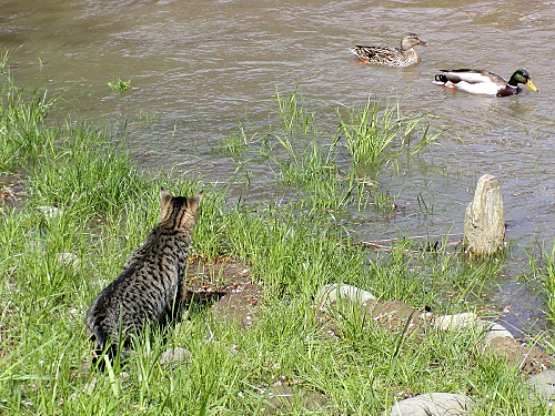
The picture above shows a lesser flood in April 2002 of 'average' proportions. The mallards were attracted to fresh dabbling grounds and our cat Jigs keenly yearned for a meeting with them, but such was not to be. The picture was taken in our labyrinth.
Friday, November 03, 2006
Nutria in the Petunias
There was an interesting observation yesterday in the heavy rain we seem to have settled into. A nutria (an import from the far end of South America), perhaps flushed from his riverside den by the rising water, discovered some patches of petunias. These were about done flowering for the season and needed to be pulled for the compost pile, having barely survived a light frost. The nutria found them a gustatory sensation, and began first chewing them off and then pulling them up. Upon inspection the following morning it was found that he(?) consumed only the tough bases, leaving the smaller stems and leaves in heaps ready for the gardener to pick up! Some plants were pulled up by the roots. The only other animal which has been seen here eating stem bases (of spring grass) was beaver.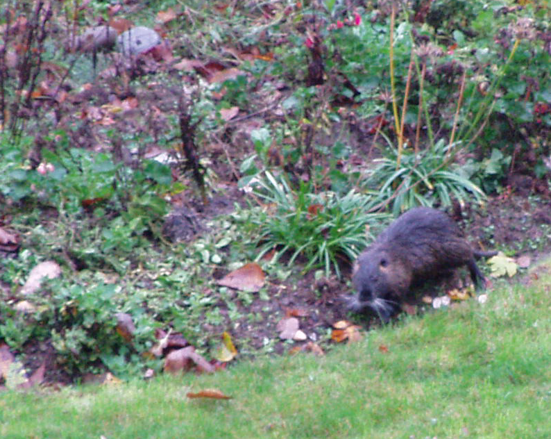
Nutrias are perhaps best described as vegetarian and partway between a beaver, a rat and especially the muskrat, and related to all three. They are aquatic and if lacking predators overuse their habitat by constant grazing. Originally imported into several parts of the USA as a boon to the fur industry, this fur-bearing animal was actually trapped heavily for the fur trade, with up to 1.8 million harvested in a single year in Louisiana alone. Fur fashions change and now demand and prices are so low that the nutria are rarely trapped and have reached pestilential status everywhere. Some states have proposed eradication as a solution to the damaged wetlands they cause. Others see them as an unsolvable nuisance.
Before the old apple tree fell, nutria would travel a long way uphill from the river to feast on the windfall fruit. They would return your gaze with a look apparently both dumbfounded and astounded before lumbering off back to the water. Though efficient swimmers they are slow on solid ground.
Thursday, November 02, 2006
Hummingbirds in the Strawberry Tree
In front of the house, along the circular drive, are three 'dwarf' strawberry shrubs. This one is very unusual in that its fruit take a full year to ripen, so flowering and fruiting overlap in time. Like some plant from the Celtic Otherworlds, the white blossoms expand among the ripening fruit from the previous year. The small blossoms that have begun to attract late-season hummingbirds - daily, at about a quarter after nine.
It is unusual for hummingbirds to visit this type of flower - but hunger is no doubt a factor. Little else is available in early November. We have a few spikes on penstemon and cape fuchsia, and some daisies, but these have suddenly become attractive to them. In spring one does not see them visiting similar flowers, such as andromeda, as more appropriate trumpet-shaped flowers are there for them then.
The strawberry tree is certainly an attractive shrub. Its reminiscent of the manzanita of America’s West, and indeed it is a close relative of it. The compact form which we have is definitely shrubby and 10 to 12 ft. high (3 to 4 m.), while the wild form from the Mediterranean is more treelike and can reach 35 ft. (11 m.) The species ranges from southwestern Ireland to Asia Minor.
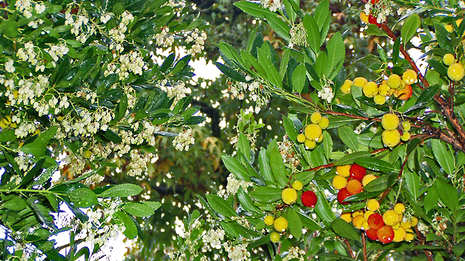
The flowers are shaped like upside-down urns, and are of typical form for the heather family. They are a clear white and are very numerous. They open over a three month Fall period for us, with a few strays towards Spring. The round fruit stays small and green through summer, and not until late in that season do some enlarge and turn yellow and then red. Like the flowers, the fruit mature over a period of months. Both flowering and fruiting can be affected by hard frosts in the northern part of the Strawberry Trees range. In milder zones both can continue into winter.
The plant is evergreen, of medium texture, and grows at a moderate to fast rate. The foliage is a medium green and the bark orange, with the new growth stems sometimes red. It accepts pruning well, and can be handled according to your desired end results. Keep it smaller and shrubby, even hedged, by cutting back strong leaders or even with shearing. If you have room, prune it up and it turns into a nicely gnarled tall shrub. If you open it up in addition, and it can be a airy screen rather than a dense hedge.
This is cold hardy rated from USDA Zones 7 to 9, or down to about zero F. (-18 C). It takes truly hot summers well - tough enough for AHS Heat Zones 3 through 9 (meaning it still thrives with up to 150 days yearly above 86 F. (30C.), or as few as 7. And the drought tolerance is great! Even in the summer-dry American West it does well with little or no water, and in summer wet climates (like the American Eastern Seaboard) it definitely is better without watering.
The botanic name is Arbutus unedo compacta.
Sunday, October 08, 2006
Clackamas Headwaters Tour
On both September 29th and October 3rd a day was spent finding some of the many source founts of the farflung Clackamas River in the high mountain reaches of the Cascades. At 900 square miles, the watershed of the Clackamas includes many forks and tributaries. We located easily accessible sources for both the Oak Grove Fork and the true source of the Clackamas proper. Some of the headwaters are inaccessible with neither road or trails to them, including several on the Warm Springs Indian Reservation.
The access route for this trip is Highway 26 over Mount Hood at Summit (Government Camp) to Forest Service Road 42. Many of the vine maples on this stretch are blazing red this time of year. After a few miles of attractive roadside forest, turn right on Forest Service Road 58 for the two mile sidetrip to Little Crater Lake. This startingly bright rich blue pool is the result of a large 34 degree (1.1 degree celsius) artesian spring eroding out soft siltstone. It formed a 45 foot deep cliff-sided basin, which has many toppled trees visible in the clear waters, preserved by the cold temperatures. The lake sits at about 3250 feet (990 m. ) elevation.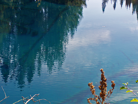
The name results from comparison to Crater Lake. This one isn’t directly the result of volcanism, but the intense blue of the water invites comparison. And early visitors were not always clear about how to discern different geologic processes.
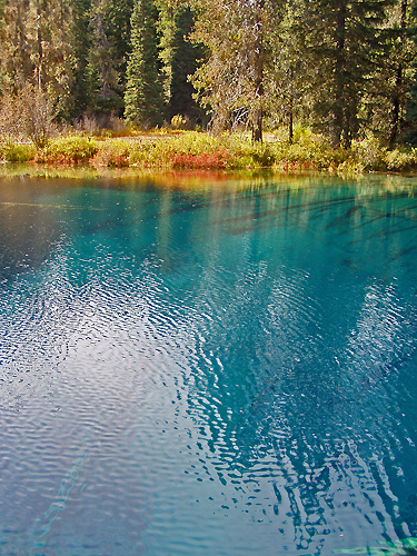
The surrounding terrain is flat and only slightly sloping. Good views of Mount Hood exist to the North. Fall color was good though most of the trees around are conifers. Shrubs provided most of the reds. In spring the meadows are worth a visit just for the wildflowers.
Next stop was the Clackamas Lake Historic Ranger Station, still in use a full hundred years since the location was selected. One structure has been turned into a small museum, and others can be rented for overnight stays. The surviving structures were built starting in the 1933 days of the Civilian Conservation Corps. The earlier structures from as far back as 1906 were built directly on the soil with little regard for longevity, and have all been torn down. The CCC structures were built to last, and the only losses have been to fire.
The 1933 Clackamas Lake District Ranger’s Office is now on the National Registry of Historic Buildings. Currently its the one used as a museum. Staff is helpful, knowledgeable and quite willing to give a talk at the drop of a hat.
A short hike takes one to Clackamas Lake and the springs that feed it. It is about 3400 feet (1036 m.) in elevation.

The lake is an unusual shade of blue, more of a clear teal really. This is due to a rare species of algae known as mares eggs. A wooden walkway extends from the campground out to the edge of the lake. A broad apron of marsh surrounds the lake, inhabited by swamp Engelmann spruce, swamp lodgepole pine, willows and a rare-in-these-parts shrub birch.The several springs are less than a yard ( 1 m.) above the lake, just enough to give a little current to the flow. Likely more springs are submerged. Beavers have cut some conifers at the springs, probably for lack of trees they actually like. A large population of monkey flowers (Mimulus guttatus) grows at the springs, now mostly dried up and gone to seed, but a single plant was green and blooming still.
The lake trail continues on in a loop through meadows and a tract of old growth. More 1930’s Forest Service facilities are included on the two mile (1.21 km.) loop. A longer loop for all day outings can take in all of Timothy Lake as well. Both loops follow the Pacific Crest Trail on parts.
Huckleberries provide much of the fall color in this section of the Mountains, as this scene along Miller trail attests. Some species are red, others purple and still others yellow, and sometimes all three can be found intermingled.
Next in line is Summit Lake, down a one mile section of gravel road (USFS Road 151), recently upgraded to good condition by filling in the sizable potholes. A campground lines some of the far side of the lake. 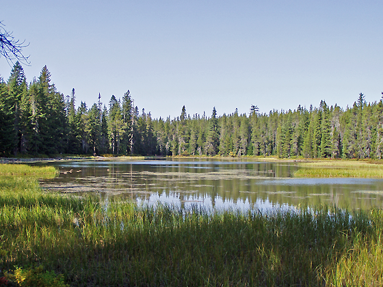 The Forest Service maps show a creek entering and exiting this lake, but no sign of flow in or out exist. Low points exist at either end, but no active channels are present.
This is a higher elevation lake than those mentioned above at about 4200 feet (1280 m.). Pacific silver fir and mountain hemlock are two species not seen previously at the lower elevation sites. Dragonflys were still mating despite the late season, soon to be freezing and collecting snow at this elevation. I’ve skied at the end of October in an early storm. Today for us it was shirtsleeve weather.
Continuing down Forest Service Road 42 it is nearly ten miles (16 km) to Forest Service Road 4220. Here someone wisely painted on the asphalt the road numbers, as the signs have disappeared too many times. A sharp left to the south, one that would easily be missed, is called for. Another 8 miles or so brings you to the glaciated lakes region of the Olallie Highlands. Here meadows, lakes and trails abound, overlooked by 7215 foot Olallie Butte.
First stop here was for a brief view of Olallie Meadows, an extensive probable former lake area bisected by the boundary of the Warm Springs Indian Reservation. A campground exists on the Forest Service side, along with an old cabin. A trail oto Reservation land reaches three high elevation lakes, and intersects with the Pacific Crest Trail.
Next stopping at Lower Lake Campground, we hiked down to the lake. It is a 1.25 mile (2 km) walk with less than a 200 foot (60 m) elevation change. The stony-floored high elevation mixed forest is open at this 4800 foot (1460 m) site. There are good views of the shallow lake as the trail passes on the North side. At the far end of the lake junctions with more trails provide access to more lakes in three directions. A short distance left of the trail is the bouldered outlet of the lake, dry this time of year but with obvious signs of flow earlier in the season. Looking back East across the length of this glacial lake is a surprise hidden until this point - Olallie Butte, looming 2500 feet higher only two miles distant.
Just a little way up the road is Head Lake, the highest source of the Clackamas tributary Squirrel Creek at about 5000 feet (1525 m.). Scenic, rockstrewn, and right on the road, this is a nice one. A small ridge separates it from Olallie Lake and streams that flow off to dry Eastern Oregon. The Pacific Crest Trail crosses the road along this ridge, one of the Trails closest passages of a resort. Over a mile long, this is the largest lake in the Olallie Highlands. The resort and its store were still active, offering rental boats, cold drinks, food and lodging. Olallie Lake Resort is well worth a visit for the rustic lakeside cabins and many recreational opportunities. Horseback riding, fishing for the oversized rainbow trout, even mountaineering in nearby Mount Jefferson Wilderness Area are among the attractions. The resort is open mid-June nearly to the end of October. Unfortunately the new owners did not see fit to keep the resort open in winter. Previously you could ski in across prepared tracks or ride in on snowcats for a winter stay. At this elevation snow is practically guaranteed November through May.
On the second trip returned home via Forest Service Road 46, known locally as Berry Creek. Making a loop of the whole trip, we travel down the mainstem of the Clackamas. However, on the first trip, we continued south to the highest lakes easily visited in the Cascades.
‘Easily’ of course is relative and only means you can drive the road in a vehicle with high road clearance and tough tires. Low slung vehicles should not attempt this route down 4220 much past Olallie Lake. And if you don’t cotton to dodging potholes, ruts and boulders next to precipices, perhaps this is not your route. But 5500 foot (1675 m.) elevation Breitenbush Lake and its campground is your reward for the attempt, along with access to a collection of lakes and flowering meadows at yet higher elevations. This is one of the few areas in Oregon where you can visit alpine meadows not on a major glaciated peak.
Following the 4220 downhill after the lake is not quite so rough. Watch for a wide pulloff on the left; an unmarked trail leads to a rarely visited waterfall. This road follows a wide bench in the middle of a long slope, rising to 4800 ft above and dropping to 3000 ft below the road. When you strike pavement, turn right to return to the Portland area via the Berry Creek route FS Road 46. A left heads you towards Salem.
